Carrizo Plain National Monument

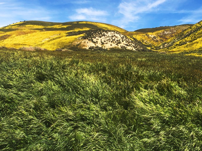
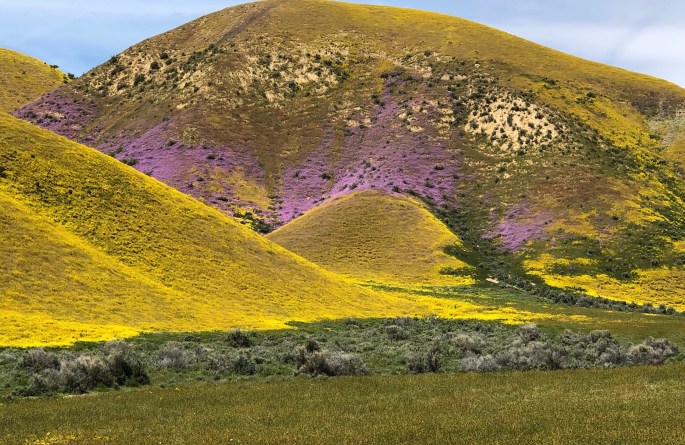
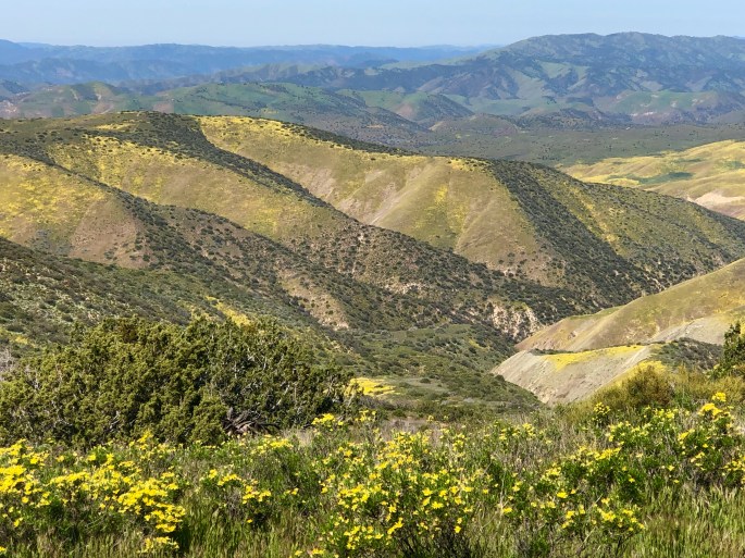
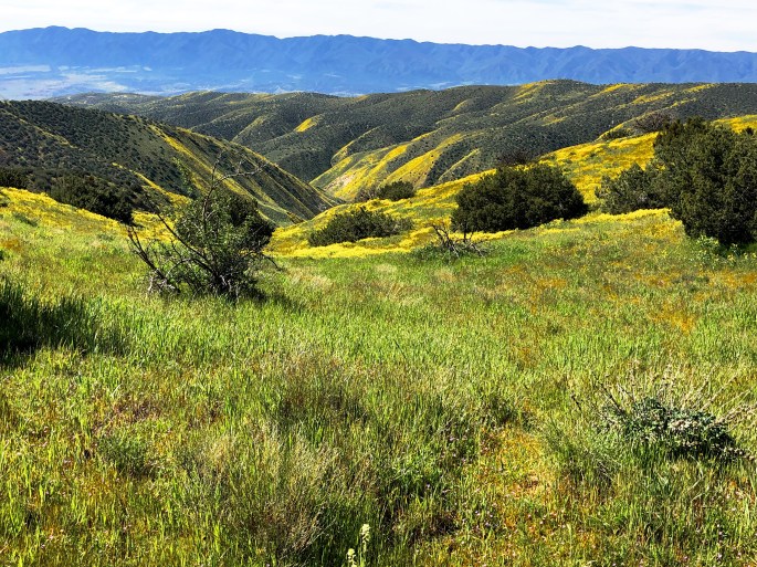
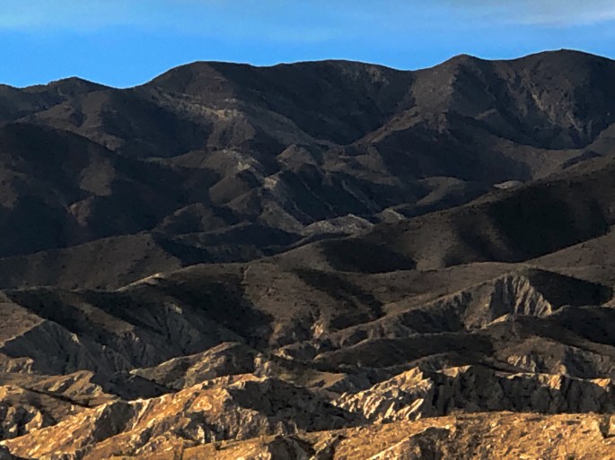
We spent three delightful days boondocking and hiking in the Carrizo Plain NM. CPNM is managed by the BLM and covers apx. 250,000 acres in San Luis Obispo County. The plain is an internal drainage basin which doesn’t sound all that appealing but it carries significant water into the 50 mile long plain which at this time of the year translates into a verdant landscape covered with colorful wildflowers. The plain runs north – south and is bounded by the Caliente Mountains on the west and the Temblor Mountains on the east. The Temblor Mountains derive its name from the spanish word terremoto which means earthquake. Uncoincidentally, the San Andres Fault runs parallel to the base of this range down the length of the plain.

The water all drains into Soda Lake.  Since this is an internal drainage with no outlet the water evaporates during the spring and summer as temperatures reach into the 100F range. What is left after the water evaporates is a salt-covered dry lake bed as you can see in the photo below.

We also spent some time walking on the Wallace Trail where you can see evidence – in the form of offset creeks and channels – of how the earth has shifted along the San Andreas Fault – which is pretty cool – as long as the earth does not shift while you are there! 

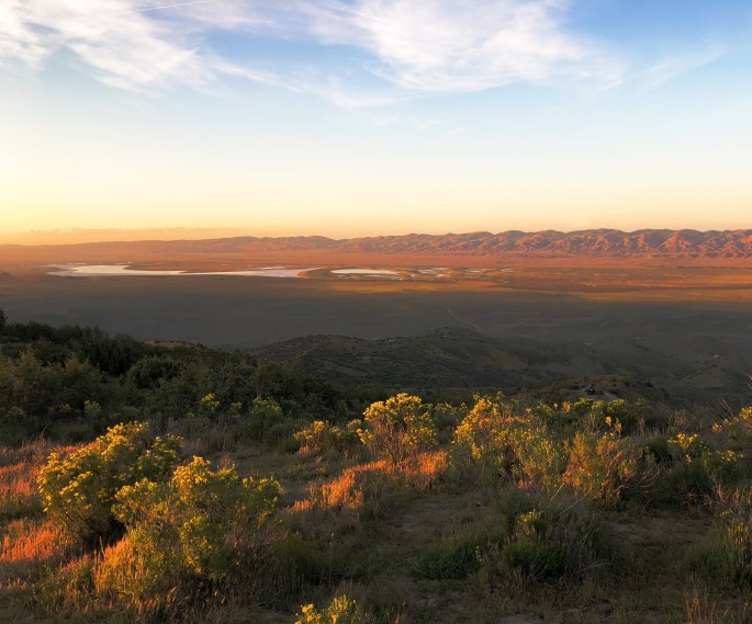
We had the good fortune to find a camping spot on the Caliente Ridge at 3700 feet which gave us a spectacular view of the plain and Soda Lake. 

We should be at Death Valley NP later this week after a stop at Red Rock Canyon.

E8539884-8FF0-4B57-B9EA-EA6810BFACE3
Carrizo Plain and Soda Lake

E56B7CD8-5685-46E4-9648-8DBC72B513E0

79FEC98B-4841-4D6E-8DD1-8E0C1A57499F

646B46FD-A6BD-4D20-BC07-B07BD89BC4F6
Sunset from Caliente Mountain

B37647A2-3F66-4773-8AE8-E71C0E21006E

F4514F1D-7322-48FC-9C0F-7BEFF90300E9

7E7E580E-F8B9-4881-92D3-820B8083F1FE


Joshua Tree National Park

After extending our stay in both San Diego and San Clemente, we are back on the road. Our first stop was at JTNP where the wildflower “super bloom” is at its peak.

JTNP is one of a limited number of National Parks that allows access to back country high clearance 4WD trails. Many of these trails exist due to the significant number of mines (300) that at various times operated in the area which is now JTNP. We took advantage of the opportunity by spending an afternoon traveling through Pinkham Canyon and were treated to spectacular scenery and solitude.

There are a number of great hiking trails within the park. Because this is the busy season at the park we chose several hikes that we thought would be less crowded including Mastodon Peak and 49 Palms Oasis.

An interesting aspect of the park is that portions of both the Colorado Desert and the Mojave Desert are within its boundaries. While the park is named after the Joshua Tree there are no Joshua Trees in the Colorado Desert area of the park; they are only found in the Mojave Desert area of the park.

JTNP is extremely beautiful at this time of the year and the temperatures are reasonable for hiking. But as this is a true desert environment we would recommend you that you visit between late fall and early spring before high temperatures go into the triple digits!

90A67640-316C-44BA-9E99-30D395A8BA1C
49 Palms Oasis – 49 Palms Canyon, JTNP
92F2BBD2-3F69-4758-9115-DE2222DF83EE
BLM Joshua Tree North Dispersed Camping

39BF1DE4-CB39-4E85-AC5A-0C8468F40EE3

755995C4-F607-43F6-B618-64AFAFFB56E8
Pinkham Canyon 4WD Trail
B4B26ADA-2CC3-4D98-AA6C-72FE7081B3AF
Rattle Snake at Mastodon Peak
34DCBD8D-98EB-4FDC-B5CC-186857FDB5E2
Ocotillo Cactus


Anza Borrego Desert

We have been enjoying the “Super Bloom” ( desert wildflowers benefiting from a wet winter) in the Colorado Desert located within the Anza Borrego State Park, California. The weather and scenery here is so idyllic that we keeping extending our stay here – moving every couple of days to a new spot in the desert to camp. 

Great hiking and exploring – temperatures averaging 75F during the day and bottoming out at 50F overnight. We have met a number of Connecticut transplants of late – fortunately all Red Sox fans.

Nothing profound from our end at the moment. Extended periods of time without connectivity is good for the soul. We are feeling very content all in all. Over and out!

BF70BDAA-4BAB-4F88-A874-C2414908810F
Boondocking in Arroyo Saleda – Borrego Badlands
FFEDF4C5-8EFF-465A-8A6D-59C21CCA4B3C
Seventeen Palms Oasis – Borrego Badlands
35945494-DF1A-4791-B339-9F073778BACD
Santa Rosa Mountains
AC6023E8-0E14-4D1B-9A88-CF7526B64214
Yaqui Wash – Anza Borrego State Park


Kofa NWR – Castle Dome Mountains

After a two day pit stop in Yuma (warning – no legit coffee!) we drove north for our final Arizona segment. We camped in the Kofa NWR in the shadow of Castle Dome Peak and then journeyed overland via McPherson Pass. As we came across the pass and began our descent into the King Valley we were treated to a panoramic view of the Kofa Mountain Range. The Kofa Mountains are named after the King of Arizona gold mine (K of A) which operated in the King Valley during the very late 1800’s. 

A storm moved through during the night bringing cold temperature, high winds and rain. However, we consider that a small price to pay for the solitude and beauty that we experienced while in the refuge, and of course the exhilaration of a 4WD overland adventure.

California, here we come!

7DC72F84-0FE7-46B7-A483-B53E19A38D41
Ferocactus
FEEDB9AA-BC89-4965-9122-A27A36DD45BE
Castle Dome Peak
05EB5010-E490-4AEF-9F04-6C7E6ADF3468
Castle Dome Mine Road

0ED9BF52-927B-4EF8-BD75-BC64EE8FF946

89C188A6-E2B9-4B48-A441-984E96160385

060E173A-4B39-4C91-B00A-C32757B16F84


Buenos Aires NWR to Tohono O’odham Nation to Ajo

After a taking three days off from the road in Bisbee we have started our journey west to California along the Mexican border. Our first day of travel took as far as the Buenos Aires NWR which lies just west of Arivaca, AZ (pop. 700).

The BANWR was created in 1985 with the purchase of 117,464 acres of land. As with all of the 585 national wildlife refuges in the U.S. the land was purchased under the authority of the Endangered Species Act. In this particular case the endangered specie was the Masked Bobwhite Quail. The U.S. Fish & Wildlife Service which manages this refuge also reintroduced grasses that had vanished from the area and Pronghorn Antelope. 

While the BANWR was created to protect an endangered specie this is public land and open for camping, hunting, horesback riding and hiking. We took advantage of the camping opportunity and were treated to a beautiful  sunset and dark sky. We saw no other humans during our stay here. From a wildlife perspective we did not see any quail but did see our first javelinas of the trip.

From BANWR we traveled through the Tohono O’odham Nation Reservation. The T.O. Nation is a 2.8 million acre reservation with a current population of apx. 14,000. Tohono O’odham means “desert people”. In this case the desert is the Sonoran desert of southwestern Arizona and Sonora, Mexico. 

The T.O. Nation extends into Mexico. The residents of T.O. consider the reservation to be one nation irrespective of the U.S. – Mexico border and believe they should be able to travel freely within the nation. The U.S. Border Patrol disagrees and this has resulted in an ongoing conflict between the two parties. Additionally, the Border Patrol wants unfettered access to the border within the reservation which the T.O. Nation is not willing to provide. 

Politics aside, we were fortunate to travel through the reservation at a time when the Sonoran Desert is in full bloom. Purple, yellow and orange flowers lined the highway against a backdrop of cacti and mountains making for breathtaking scenery.

We stopped briefly in Ajo just west of the T.O. Nation before proceeding to Yuma. Ajo was another town which came into existence as a result of a large copper mining operation which is now defunct. The art work pictured below is part of an arts project in Ajo.

4B6A2A7E-DC08-4761-8BD9-5CB22E67DCBC
Baboquivari Peak – Tohono O’odham Nahtion
C823D210-9E00-40DA-9B05-DBF197651BC1
Buenos Aires National Wildlife Refuge
77631245-9B08-456B-ADBA-ED17E30AD09F
Sunset Sonora, Mexico
85D4CDFD-E3E3-4C91-A981-8BA279DC26A8
Entering Wilderness Area

AF02C3A2-752F-48E9-A0E7-65FD65CD8F1A

54D27B13-49E2-416B-89A0-E9D89359B4C0
Tohono O’odham Nation Opposes Border Wall

2FA872CE-21C8-491E-B0A2-782A4D384956

Chirachua Mountains

After three days in the Dragoon Mountains we ventured east to hike and camp in the Chirachua Mountains. The Chirachua are about twice the size of the Dragoon Mountains, 35 miles long and 21 miles wide. Chirachua Peak, at 9800 feet, is the tallest peak in the range. The Chirachua Mountain range is an officially designated Sky Island.

Chirachua National Monument, which is managed by the NPS, sits at the northern end of the range. It contains numerous rugged canyons with a spectacular array of pinnacles, hoodoos, capstones and balance rocks. The hiking is strenuous but the payoff of dramatic scenery and vistas is well worth the effort.

The majority of the mountain range lies within the Coronado National Forest giving us access to dispersed camping close to the trails in the national monument.

We left from our campsite via Forest Road 42, traversing through the range exiting in Portal, Arizona. We were treated to stunning vistas as we wound our way up through the range and down the western slope toward New Mexico. 

C1836E9D-3016-44C6-B1E1-D2F4636EA50D

FD303100-AC52-4F59-B0D3-9713D28730A1
North Bonita Canyon
D1DDC72A-21CD-40D0-8469-2496D346D75B
Echo Canyon

93A425BE-EC63-45F3-9430-225588C7070E

96877E54-7335-49E2-AFF3-5C528A51D694
Hailstone Trail

Sedona, Arizona

The scenery in Sedona is just as breathtaking as we remembered from our last visit many years ago. The town itself has grown substantially and become a major tourist destination. None the less we had a great time here as we found solitude while we hiked in the Red Rocks and boondocked under the stars in the Coconino NF. 

The coffee scene was limited so we are not posting any highlights in that regard.

Departing for the Valley of the Gods in the morning. 0081,0082,0083,0084

71F9548F-2CF1-4791-BC48-8E93D3E62EC0
Boynton Canyon
DD6DED2C-B614-494F-ADA2-1E506384A344
Boynton Vista

B414B877-B154-468A-86C9-FED20EF4385A

9E963EE0-E2B0-44F7-A60B-90F586692ED4
Munds Wilderness from Submarine Rock
7980F32F-7824-438B-BC01-202DBA33CC1A
Wilson Mountain from Brins Mesa Trail
8329822C-CC95-4920-8D03-386D2446C837
Mormon Canyon


Southern Utah Part 2

We have been taking full advantage of the great weather to boondock and hike in the Hurricane area and Zion NP. We also had an great afternoon on the dunes in Sand Hollow. We have arived in Kanab after about a four hour wait as a section of the Smithsonian Butte was impassable due to a strom that passed through early this morning. Fortunately the Sun appeared with a light breeze to help the road dry out enough for us to make it through the clay section. If the weather remains dry over the next several days we will be able to hike in several exciting slot canyons in the nearby Vermillion Cliffs area.


5F5D9205-C262-4DE3-9BB9-418D310C2CDD

8966DFAC-2918-418F-8D93-1CB74C66E16B
Pizza Night
EF59E057-DC82-4654-8BBC-39D190931706
Boondocking on Grafton Mesa
14740F96-9AF3-4A14-943B-9E8D205D5F8C
Zion NP from Rockville Mesa 
E5161E30-9C5D-479D-88BD-F14D5E708C97
Boondocking on Rockville Mesa

72A824F3-A6B1-4FD7-8182-265779C8D248

964016DF-A1FF-41E7-B54A-943C0F2D7FFC
Sand Hollow

Southern Utah

We have journeyed to Southern Utah near the Arizona border and we are enjoying the beautiful weather. Enjoying Fika with our old friends at River Rock Roasting in La Verkin. Camping in the Dixie NF under breathtaking night sky. Phenomenal scenery, hiking and scrambling! Not sure what else to say…..life is good. 0065,0066,0067,0068,0069

92C97CBE-7196-4204-9C1F-5F2509147FFD

2781EC26-5986-4455-B773-3F771BB47645

77BBC502-708E-4945-9F0F-E87D68E2F7D5

FCD9B55F-81E1-4FB4-8CF2-E976514B4CDD

Red Cliff Recreation Area

09DA180B-231B-4FB4-B059-C8F2079480C4
Red Reef, Leeds, Utah

Dixie NF, Silver Reef, Utah

Fish Lake NF, Kanosh, UT

C7AD9FE6-38BA-4804-88F4-B2DCDF3643D5
La Barba Coffee, Draper, Utah

Badlands National Park and Buffalo National Grassland

From Rapid City we looped back east to spend some time in Badlands NP. We had fabulous weather which enhanced the spectacular scenery. We did several short hikes and were fortunate to catch spectacular sunsets. We also took advantage of the Baja Motorized Travel Area within Buffalo Gap to spend some time driving overland and putting the “Beast” to the test on some great terrain.

688A04C5-EFD5-4E18-B61A-5FDC8CC2B990

23F13305-F829-4B62-A695-47350E847A3A
Baja Motorized Travel Area

369CBF50-90F1-4820-9678-E5D81D94182F

0E42B63D-0A1E-42B1-9B13-657934A7E3EA

EBEDC9B4-B6FB-43D6-BD16-AA70DD5A9B0B.jpeg

13DDA9B5-9110-42BA-BE42-117BCEA610DD.jpeg
Gold Mounds

B085D10B-AA2A-4928-9416-8620E4660CC4

8F2A8A5F-9F96-43CC-9B5F-8E46246B1DDD