
From the Tumacacori Mission we made the hour drive to Tucson – first stop Presta Coffee – excellent Cortados! Always fun to return to one of your favorites!


Tucson’s origins date back to the 1770s when the Spanish built a presidio here to stop the westward movement of the French from the Gulf of Mexico (yes-Mexico!). At that time Tucson was the northern frontier of New Spain and there was a well- established line of missions throughout the area dating back to the early 1700s and the work of Padre Kino and the Jesuits ( see previous post: Tumacacori National Historical Park).
Hotel Mccoy
A s we have accumulated more time on the road we have come to appreciate smaller and more unique hotel accommodations when we are not camping in the Beast.


The Hotel McCoy in Tucson (there are three in total – the other locations are in Texas and Washington) is a renovated mid-century motor court hotel. Logistically, we were drawn by its proximity to downtown and the light rail. More importantly, we like to see older properties renovated and brought back to life, as the McCoy has done in Tucson. Additionally, any accommodation that promotes local art, live music, coffee, beer and wine has our attention. The murals pictured below are a sample of the murals on the exterior walls. Fine art is on display in all the rooms and lobby/bar area.


We enjoyed our stay for all of the reasons we have mentioned above; in addition, all of the hotel staff were quite friendly and focused on meeting our needs.
barrio viejo

The barrio represents one of the best examples of the Sonoran Adobe architecture utilized by Spanish and Mexican settlers. Most of the buildings and dwellings were constructed between 1860 and 1900. Unfortunately, a significant portion of the barrio was demolished under the guise of urban renewal. Thankfully, the community was able to halt the demolition of the entire neighborhood and what exists today is protected as a National Historic District.

The barrio that exists today is quite handsome. It is also quite gentrified and no longer home to the working class Mexicans that lived here for many decades. In our opinion, this neighborhood is absolutely worth spending time to explore. Also, several of the corner buildings are occupied by excellent restaurants (more on that later).


Downtown – Congress & Broadway
The downtown entertainment and shopping district is packed into several blocks on Congress and Broadway. The district is anchored by the Congress Hotel, a local landmark. The hotel opened in 1919 and closed in 1934 as a result of a major fire. The hotel reopened in 1940 albeit with just 40 rooms in lieu of the original 80 rooms. The hotel presents live music seven nights a week in multiple venues. Jazz is on tap every evening. Photos below courtesy of the hotel.


Street murals are all around town with a significant concentration downtown. Some of our favorites are pictured below.


We mentioned the light rail earlier in the post. The Sun Link routes allow people to travel from the west end at the Mercado (near our hotel) through downtown, the Fourth Avenue District and out to the university in the east end. Quite convenient and FREE! We really appreciate not having to take the van into downtown areas in larger cities.

Fourth Avenue – Boho
Fourth Street is regarded as the Boho or Hippie area of Tucson and appropriately so. The district is just north of downtown and full of all sorts of small shops-vintage clothing, art, home decor, vinyl and plenty of eateries and bars. The area is also home to a fair number of murals (we have photos of a couple below). It is a fun neighborhood to explore on foot and pop into the shops (and maybe a bar or two).


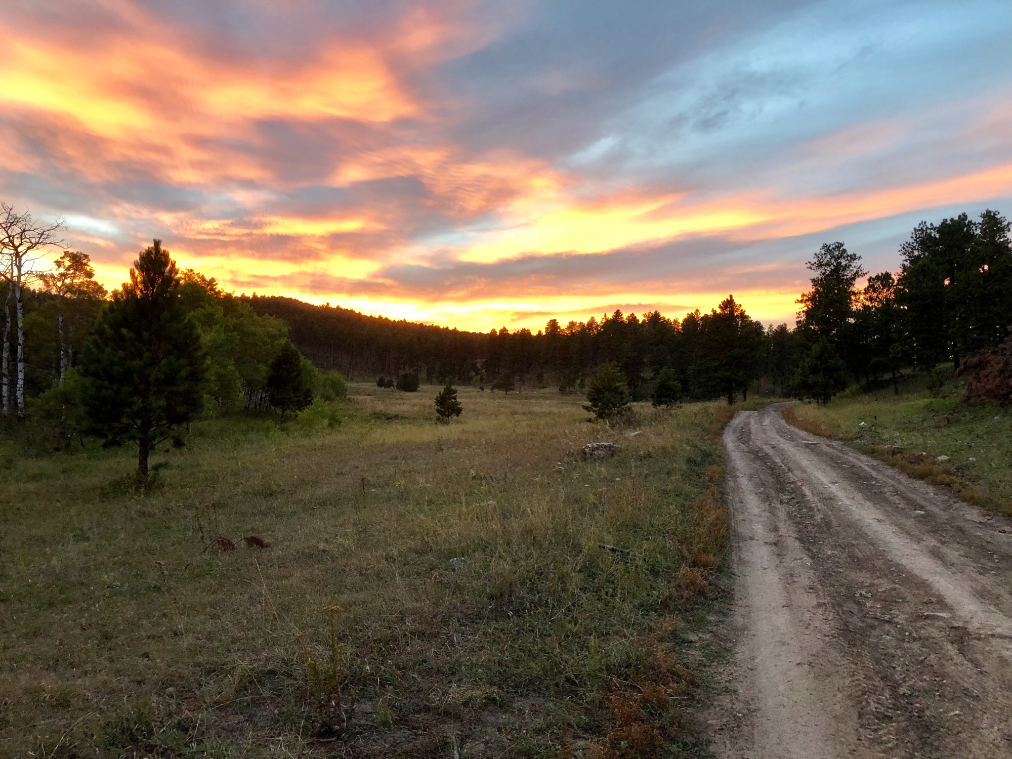
Redington Pass
After several days touring around town using the light rail we fired up the Beast to take an afternoon road trip to the Redington Pass which is east of Tucson in the Coronado National Forest. The road (Forest Road 371) climbs up and over the pass between the Santa Catalina and Rincon Mountains and then descends into the San Pedro River Valley.


The pavement ends at mile marker three as the rough dirt road begins the winding climb to the pass.
We stopped at the pass to take in the distant views. Recreational target shooting is legal in this area of the Coronado National Forest and we took advantage of the opportunity before proceeding down into the San Pedro River Valley. This area is also cattle country. The Bellota Ranch (bay-OH-ta) has been here since 1875. It was founded by the Redfield brothers, who had migrated from New York. The ranch is no longer owned by the Redfield family but it is still operational as a cattle ranch (plenty of evidence of that scattered everywhere!).


As we proceeded down the west side of the mountain we entered into a zone filled with Saguaro cacti and green farm fields further off in the heart of the river valley. Quite beautiful!


Once down onto the valley floor we follow the road north before making a right turn onto East Redfield Canyon Road. The road takes us past what appeared to be a small abandoned settlement (it was at one time) but upon further investigation all that remains is the Carlink Ranch. The family farm and ranch was established in 1884 and is now under the care of the sixth generation of the Smallhouse family. The Carlink sells cattle, cacti and wood. The independent spirit of the West lives on!

From the Carlink we traveled north along the San Pedro Valley River to San Manuel and then passed to the north of Mt. Lemmon and finally headed south back to Tucson and a well earned dinner (and perhaps a cocktail).
Bicycling
Tucson has many miles of bike trails. We threw a figurative dart at the board and opted for the Rillito River Path. This section of the path follows the bank of the river for a bit over 23 miles. Perfect bicycling weather – 75F, sunny, no wind and no humidity!


https://www.alltrails.com/trail/us/arizona/rillito-river-path
fika & food
Tucson as a city of almost 550,000 has plenty of excellent dining options from taco trucks to full on fine dining. And, of course, many specialty coffee shops to sample.
Our all around favorite on this visit was the Coronet which consists of a cafe, a fine dining restaurant and the Nightjar Craft Cocktail Bar. The Coronet is located approximately one mile from our hotel in an absolutely gorgeous 160 year old Spanish style building in the Barrio Viejo. As you might infer from the sheer number of photos from the Coronet this was our “go to” eatery while in Tucson. We enjoyed breakfast, lunch and dinner at the Coronet (not on the same day!).


We also recommend the Five Points Market and Restaurant. The restaurant sits at a five way intersection which joins multiple barrios. It has a very simple interior but the food is excellent. They also have small but excellent wine list well matched to their dinner offerings.

For drinks and small plates we recommend the Crisol Bar. The Crisol is also located in the Barrio Viejo and co-located with the Exo Roast Company. Very convenient!! We did not partake but the Crisol is locally well known to be the place to go if you are mezcal aficionado. Para todo mal, mezcal… y para todo bien tambien. When things are bad, mezcal… and when good, the same.


There are many great attractions in Tucson that we have not covered in this post primarily because we have visited them on previous visits to Tucson. We have listed our top recommendations below.
- Saguaro National Park
- Sabino Canyon Recreation Area
- Pima Air and Space Museum
- San Xavier del Bac Mission
- Mt Lemmon
- Tucson Museum Of Art
We will post next on our time in the King of Arizona National Wildlife Refuge which is located about 40 miles north of the Yuma Army Proving Ground in the Northern Sonoran Desert. Yes, back to the desert!
Be seeing you!


P.S. Ts-iuk-shan is the Tohono O’odham name for Signal Mountain in Tucson. Tucson is a bastardization of the name given by the original inhabitants.


